Stevenage Old Town
Pictures of the High Street
By V Richards
The Bowling Green, High Street
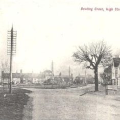
Bowling Green 1906
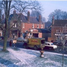
Taken from the Bowling Green. Culpins Shoe Shop is the nearest shop - the one behind it is (or later became) Bickells jewellers. The road between them is Orchard Road. Bickells was demolished to make way for the new road in the 1970s.
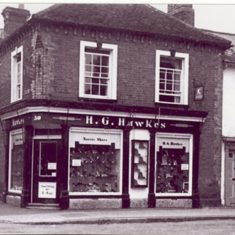
H.G. Hawkes shoe shop, which stood on the corner of Orchard Road and the High Street. The shop to the right was the Moathouse greengrocers.
C.A. Hawkes
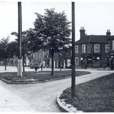
Northern end of the High Street. The large building behind the tree is the post office. The pub to the right is the Yorkshire Grey.
C.A. Hawkes
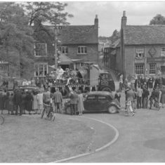
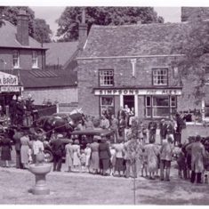
The annual carnival procession passing the Two Diamonds pub in the High Street.
C.A. Hawkes
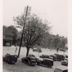
High Street. The shop on the left in the background is Moss grocers, which was on the corner of the High Street and Walkern Road. The large building in the background is the Cromwell Hotel.
C.A. Hawkes
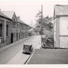
Orchard Road - the large building on the left is the old Town Hall
C.A.Hawkes
Stevenage Carnival passing the Yorkshire Grey PH in the High Street
C.A. Hawkes
The northern end of the High Street, with the Yorkshire Grey pub on the right, and the post office behind the tree.
C.A. Hawkes
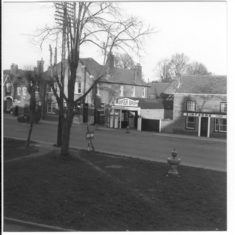
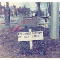
A sad picture taken at the northern end of the High Street, reflecting local feeling when the new road was put through in the 1970s.
Here are a few old photographs of Stevenage – mostly the northern end of the High Street.
This page was added on 04/07/2013.



Add your comment about this page
G.G. Hawkes [H.G., according to the caption in the post. Ed.] is now the Papa John’s in the Old Town, on the other side of the one way system [The other side from what, I wonder? Ed.]
No. 32 used to be the jeweller’s but got knocked down.
Old photos are always seen as nostalgic, and I had no idea the High Street had a green as well as the bowling green. What makes me sad is that, when proposing a whole new town (of predominantly the same style of houses as each other) they destroyed so much of the old houses in the Old Town that you cannot replace. However, what makes me even sadder is that they destroyed the Town Hall! Fancy proposing a ‘wonderful new town’ bringing in 60k people but destroying the main focal point that already existed (town hall) and ruining the high street, the shops, the churches and the community by trunkcating it at both ends. Sad
To Emily Smith
Are u still there above Hawkes shoe shop, 30 High Street? They were my grandparents.
Margaret Whittington (Gafford). Now in Somerset.
Can you tell me what the post office was before it became the post office.?13a high street Stevenage.
There’s a short account of the Publix on this website under “Sport and Leisure/Publix cinema 1961”.
I think it was Derren Nesbitt’s fault the road changed, because he he did not want his house pulled down.
Me and my brother use to go to the publix. Whats the history of the publix?
Ah, it was so sad to read that last little comment about your dad. How very sad, and how bloody ignorant of the powers that be to put profit before integrity, they should be sued or made to put it right, I mean, as you say, there’s no sense to it, most towns have a bypass which relieves the town of the increasing volume of traffic so what’s the sense of having that but then destroying the high street.
my family moved to Stevenage new town in 1959/60 when I was 2, they are still there but I moved to Surrey when I was 17. My brother went to the ancient school in the old town (Alleynes?), but my best mate at secondary school was a guy called Rodney Amis who’s dad owned the bicycle shop on the high street, Bowyers was it? I’ll ask Rodders later about that! Lolx.
Thankyou for your interesting article and those wonderful pictures. X
I really have to comment on the last picture. It is indeed sad. The green was the heart of the old town and as the photos clearly demonstrate, there was much soul and character here, and I lived close to it as a child. There was a lot of opposition to the new road, and though we could understand it, we never understood why it had to be routed around the green and not wholly behind the shops where Lytton way is now, preserving the integrity of this part of town. My father is well into his 80s and still very fit, but I cannot talk about it as even now he gets upset.
The Publix did not just have fleas but Rats !!!as they invaded our house next door (on the left) when they knocked,or should I say pushed it down by hand as the cement was rotten !! back in the late 1960’s
In the first picture was the White building the old PUBLIX CINEMA ? Known to us oldies as the Flea Pit.
Fascinating pictures. We live above the shoe shop now and it seems as though many of the pictures were taken from our front room which faces 2dry ( or then the two of Diamonds). I would love to get in touch with the family who used to live/run the shoe shop or premesis above. Many thanks, Emily.
The grassy area in the second picture is not the Bowling Green, but The Green, which is something else entirely! The Bowling Green is simply the triangle on which the War Memorial stands and is seen in the first picture before the first World War, even though in recent years a dentist alongside The Green has rather strangely taken on the name Bowling Green Dentists. The Green (which in the 19th century stretched all the way down to where Cinnabar now is) was badly butchered by the Road 10 scheme in the 1970s (see the final picture!) and has suffered from having shrubs planted on but in its truncated form is still with us and as Stevenage’s closest thing to a village green, is a very important historic communal space.